Share


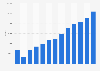
The global Aerial Mapping Surveying Sensor System market size was valued at approximately USD 3.5 billion in 2025 and is projected to reach USD 8.6 billion by 2035, growing at a CAGR of 8.9% during the forecast period.
Aerial mapping surveying sensor systems represent a critical market segment within the technology-driven geospatial industry. These systems encompass a variety of products and solutions including LiDAR, photogrammetry, and multispectral imaging sensors that are deployed in aerial platforms like drones and aircraft. The primary purpose of these systems is to gather detailed spatial data and imagery for applications in land surveying, urban planning, agriculture, and environmental monitoring.
The market is an integral component of the broader geospatial industry ecosystem, serving a diverse array of end-use applications that demand precision in data collection and analysis. It garners significant attention from technology developers, governmental entities, and consultancy firms. As a technology-driven market, constant innovation drives growth, while major stakeholders include technology providers, surveyors, urban planners, agricultural analysts, and regulatory bodies. Over the coming years, the market is expected to mature, fueled by strategic technological advancements and evolving end-user requirements, propelling it into a phase of technological integration and increased precision.
This segment accounts for approximately 30% of the overall market. The division by product type is vital as different sensor systems offer unique capabilities and functionalities fitting distinct market niches and user needs. LiDAR sensors, for instance, fetch a premium owing to their high accuracy in topographic mapping, creating substantial demand across industries like forestry and construction. The diversity in product offerings allows companies to align their portfolios with specific end-user requirements, thereby influencing the competitive landscape and pricing strategies significantly.
LiDAR Systems “ 40%: LiDAR systems hold the largest share within this category, attributed to their precision and efficiency in capturing high-definition 3D data for topographical applications.
Photogrammetry Systems “ 35%: Photogrammetry systems follow due to their cost-efficient nature and extensive application in creating orthomosaics and 3D models in urban planning and construction.
Multispectral Imaging Systems “ 25%: Multispectral imaging systems account for the remaining share, primarily utilized in precision agriculture and environmental monitoring for assessing plant health and resource estimation.
With an estimated market share of 40%, this segment represents one of the major contributors to industry revenue. Applications drive market segmentation as they indicate usage patterns and adoption rates across varying industries. High-precision mapping in construction and urban development sectors sees robust expenditure, thus significantly contributing to the market revenue. Additionally, the broadening applications in environmental monitoring further accentuates the critical role applications play in market structure and dynamics.
Urban Planning “ 45%: Dominating the segment due to increasing urbanization and need for precise geospatial data in infrastructure development projects.
Agriculture and Forestry “ 30%: Substantial due to the increasing demand for precision agriculture techniques and forest management practices.
Environmental Monitoring “ 25%: Served the remaining part of this category by providing crucial data for climate change studies and biodiversity assessment.
This segment encompasses approximately 20% of the market, underscoring the critical influence of technological advancements on market dynamics. The segmentation by technology aligns with the rapid evolution in data acquisition and processing methods. As processing technologies like AI and machine learning become more integral, they facilitate improved data analysis capabilities and better product offerings, allowing providers to maintain competitive advantage through innovation-driven differentiation.
AI Integration “ 50%: AI integration leads this category, enhancing data processing and analysis capabilities, and offering significant automation improvements.
Machine Learning “ 30%: Drives substantial growth through predictive analytics and pattern recognition capabilities in data processing and mapping.
Cloud Computing “ 20%: Completes the category by providing scalable solutions for data storage and processing, crucial for handling large datasets typical in aerial surveys.
Accounting for 10% of the total market, this segmentation category sheds light on the diverse industry applications, propelling demand and catalyzing technological deployment. Different industries including construction, agriculture, and environmental monitoring have varied technical requirements influencing the selection of sensor systems. Industry-specific regulatory standards further shape product development and distribution strategies, impacting the overall market dynamics and structuring competitive behavior.
Construction “ 35%: Predominates due to its extensive usage in structural mapping and site analysis.
Agriculture “ 40%: Surpasses other segments by addressing efficiency and productivity demands through innovative precision farming tools.
Environmental Agencies “ 25%: Focused on providing comprehensive data for analysis related to environmental conservation efforts and regulatory reporting.
| Impact Factor | (~) % Impact on CAGR Forecast | Geographic Relevance | Impact Timeline |
|---|---|---|---|
| Rapid Urbanization | +1.2% | Global | Medium to Long Term |
| Technological Advancements | +1.5% | North America | Medium Term |
| Environmental Monitoring Needs | +1.1% | Europe | Long Term |
| Increase in Precision Agriculture | +1.3% | Asia Pacific | Medium Term |
| Government Initiatives | +0.9% | Global | Short to Medium Term |
The global aerial mapping surveying sensor system market is experiencing heightened growth fueled by urbanization trends and ongoing technological innovations, favoring new applications and broader adoption across key regions.
| Impact Factor | (~) % Impact on CAGR Forecast | Geographic Relevance | Impact Timeline |
|---|---|---|---|
| Regulatory Challenges | -1.0% | Europe | Medium Term |
| High Initial Investment Costs | -1.2% | North America | Short to Medium Term |
| Technical Complexity and Skilled Workforce Requirement | -1.1% | Global | Medium Term |
| Data Privacy Concerns | -0.8% | Global | Medium Term |
| Limited Awareness in Developing Regions | -0.9% | Africa | Long Term |
Challenges such as regulatory compliance and the steep initial investment required hinder market adoption, affecting growth trajectories, especially in diverse and regulation-intense markets.
The aerial mapping surveying sensor system market has undergone significant evolution, characterized by initial development focusing on basic aerial imagery and mapping to today™s advanced data capture systems leveraging AI and machine learning. Current market growth is being driven by substantial capital investments in technology and infrastructure due to increased demand for high-precision geospatial data.
Historically, market growth was spurred by limited application coverage, but current dynamics showcase a broad application spectrum, leading to higher penetration rates and replacement cycles, particularly in well-developed regions. Innovation is not only a key driver but also reshaping industry cost structures and competitive paradigms, leading to strategic shifts in CAPEX allocation. The intensifying focus on sustainable practices and regulatory compliance also fuels investment in newer, more efficient systems.
Technological evolution is at the forefront, with notable advancements in LiDAR, photogrammetry, and multispectral technologies enriching market offerings. Companies are actively engaged in R&D activities to streamline sensor capabilities, creating an innovation pipeline rich with upgraded functionalities and enhanced data processing capabilities. Patents for various data acquisition improvements are abundant, facilitating competitive differentiation and market expansion.
The industry is seeing significant digital transformation enabled by AI and automation, which optimizes operational efficiencies while impacting pricing models positively. As a result, adoption rates increase as businesses transition to more integrated and intelligent systems that promise higher data accuracy and operational efficiencies from supplier ecosystems to consumer applications.
Within the value chain, technology providers and component suppliers play pivotal roles, each impacting cost and profit dynamics through innovations and operational capabilities. The upstream ecosystem sees fair competition among component manufacturers ensuring competitive pricing and reliability. Midstream activities involve advanced manufacturing techniques, emphasizing technological capabilities and high capacity utilization rates, optimizing profitability. Downstream, customers such as urban planners, agricultural experts, and environmental agencies determine demand through distribution networks focusing on detailed and custom-tailored information services.
Discussions with industry participants reveal supply chain resilience as a crucial consideration, given inevitable disruptions. Comprehensive cost structures, margin distributions, and pricing strategies highlight high-value returns despite upfront investment demands.
Regulation and policy intricately affect market trajectory through compliance mandates across varying regions, especially in data-sensitive environments. Requirements for operational certification and continuous adherence to evolving industry standards weigh heavily on strategic planning, impacting market entry as well as operational costs. However, regulatory environments also drive innovation, pushing companies to innovate within constraints, improving both competitive standing and overall market maturity.
North America: Accounting for the largest market share globally, North America's growth is fueled by well-established industries with significant investment in technological advancements. Matured regulatory frameworks assist in fostering innovation and market dynamism.
Europe: Characterized by stringent data protection regulations and a strong inclination towards sustainability, Europe holds the second-largest market share by emphasizing comprehensive adoption trends.
Asia Pacific: Displaying robust growth potential through manufacturing advantages, particularly cost-effective production and growing demand from agriculture and urban planning sectors.
Latin America: Emerging with untapped opportunities, the region focuses on modernizing infrastructure and increasing application in various sectors, including urban development and environmental conservation.
Middle East & Africa: While constituting the smallest market share, ongoing market development initiatives paired with strategic alliances and government-backed projects hint at long-term potential.
The market is characterized by a fragmented structure, presenting an array of players ranging from start-ups to established key firms. Leading companies command significant market positioning with diverse product portfolios and expansive geographical reach. Notable industry players engage in strategies centered around product innovation, strategic partnerships, mergers, acquisitions, and geographical expansions to enhance their market share.
The report evaluates competitive benchmarking, company positioning matrix, and market share analysis, offering insights into strategic advancements by pioneer organizations within the market ecosystem.
The Porter Five Forces framework indicates competitive rivalry level is medium, driven by a healthy mix of established companies and newcomers. The PESTLE analysis underlines economic factors and technological evolution as significant, while market attractiveness is poised for strategic investments, given the evolving regulatory landscape and substantial growth potential in emerging regions.
Over the next 5“10 years, the aerial mapping surveying sensor system market presents a high-attractiveness proposition for investment and strategic alignment. Companies should strategically prioritize segments such as AI integration and applications in urban planning for substantial growth. Regions like Asia Pacific offer promising growth opportunities as they spearhead expansion pressures.
By closely monitoring emerging regulatory frameworks and technological trends, companies can mitigate risks while investing in capabilities that drive competitive differentiation. Building these capabilities will be paramount as the market gears towards a future dominated by technological integration, spatial data optimization, and precision mapping services.
To get full access to our Market Insights, you need a Professional Account or a Business Suite.


You will receive an email from our Business Development Manager. Please be sure to check your SPAM/JUNK folder too.
You will receive an email from our Business Development Manager. Please be sure to check your SPAM/JUNK folder too.
Our customers work more efficiently and benefit from