Share


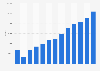
The global Satellite Photography Service Market size was valued at approximately USD 5.8 billion in 2025 and is projected to reach USD 10.5 billion by 2035, growing at a CAGR of 6.1% during the forecast period. This market encompasses services provided by both companies and governmental organizations utilizing satellite imagery to offer geographic and environmental data across diverse sectors. Satellite photography includes earth observation, mapping, agricultural monitoring, urban planning, and natural resource management within its scope.
The market operates within a technology-driven ecosystem where advancements in satellite technology and data analytics continue to drive demand. With major applications across industries such as agriculture, defense, environmental monitoring, and urban planning, the satellite photography market fulfills critical roles in decision-making and operational planning. Key stakeholders include satellite operators, government agencies, private sector enterprises, data analytics companies, and research organizations.
The industry has evolved significantly with the increased availability of high-resolution images and improved processing capabilities. It is currently in a growth-oriented maturity stage, driven by strategic expansion in applications and technology infusions. The transformation of this market is strategically important due to its role in providing data-driven solutions for major global challenges such as climate change, natural disasters, and urban development, positioning it as a cornerstone in modern infrastructure planning.
With an estimated market share of 40%, this segment represents a major contributor to industry revenue. Diverse product types cater to varying consumer needs, technological capabilities, and pricing strategies. The distinctive value offered by different satellite photography products supports specialized applications, leading to a larger market presence.
High-Resolution Imagery – 45%: High-resolution imagery leads the product category with widespread use in agriculture and urban planning requiring detailed spatial data.
Low-Resolution Imagery – 35%: This segment holds significant importance for broad-area environmental monitoring where scope over detail is a priority.
Hyperspectral Imaging – 20%: Though niche, hyperspectral imaging shows notable contribution due to increasing agricultural and scientific research demands.
This segment accounts for approximately 35% of the overall market. Segmentation by application reflects distinct usage patterns and demand dynamics across sectors such as defense, environmental monitoring, agriculture, and disaster management. Applications demand distinct data precision, rendering this segmentation key for targeted product offerings.
Environmental Monitoring – 40%: Environmental monitoring ranks highest due to increasing global emphasis on climate and resource management.
Agricultural Monitoring – 30%: Capturing 30% share, agriculture benefits from satellite imagery with precision farming and crop monitoring use cases.
Defense & Security – 30%: Critical for national security, the defense and security sector relies on precise topographic and spatial data integration.
This category accounts for 15% of the market. Differentiation by technology encapsulates various technological capabilities of satellite operations, impacting functionality and adoption levels. Technological advancement is a critical factor for competitive positioning and market penetration.
Optical Imaging – 50%: Optical imaging dominates due to its versatility and the visual clarity it offers across multiple applications.
Radar Imaging – 50%: Equally critical, radar technology supports applications under all weather conditions and at night, enhancing its utility.
This segment holds approximately 10% of the market. Segmentation by industry is vital as diverse sectors such as agriculture, defense, and government agencies have specific data needs, operational workflows, and investment capacities.
Agriculture – 40%: The agricultural sector stands out due to its growing reliance on data-driven decision-making for enhancing yield and resource efficiency.
Defense – 35%: Defense importance remains high for strategic surveillance and area assessment.
Urban Planning – 25%: Urban infrastructure planning benefits substantially from detailed and extensive geographic data analyses.
| Impact Factor | (~) % Impact on CAGR Forecast | Geographic Relevance | Impact Timeline |
|---|---|---|---|
| Increased use in Agriculture | +1.2% | Global | Medium Term |
| Surge in Disaster Monitoring | +1.0% | North America | Short to Medium Term |
| Data Analytics Integration | +1.4% | Global | Medium to Long Term |
| Technological Advancement | +1.5% | Asia Pacific | Medium Term |
| Governmental Initiatives | +1.8% | Europe | Long Term |
Growing adoption in agriculture and disaster monitoring are boosting market growth, supported by technological advances and government initiatives emphasizing regional strategic developments.
The Satellite Photography Service Market has witnessed robust growth from its nascent stages, transitioning from exclusive governmental use towards wide commercial applications. Current trends indicate substantial growth potential as navigation systems, geographical monitoring, and environmental surveys increasingly rely on satellite imagery. Consumption is marked by rising demand in precision agriculture and unparalleled geographic informativeness for global cities.
Investment trends reveal significant expansion activity, notably in payload development and launch capabilities. The market benefits from technology innovations such as cloud computing and AI integration, enhancing analytic capabilities in data-rich sectors. Cost barriers remain a challenge, significantly due to manufacturing and maintenance expenses of satellite infrastructure. However, anticipated technological advancements and geographic expansion present lucrative growth opportunities.
Regulatory support remains a critical driver as governments globally recognize the need for improved disaster preparedness, urban management, and climate responsiveness. As the market advances, growth will likely stem from further integration of innovative analytics, increased adoption of AI and IoT, and continued technology dissemination globally. These developments factor predominantly into the projected market trajectory, driven by both new adoptions and higher market penetration.
Within the Satellite Photography Service Market, high-resolution imagery leads in market contribution due to its prevalent use in diverse, high-demand sectors such as agriculture and defense. Its dominance pertains to its scope for detailed geographic information which is indispensable in many applications. Fastest growth is expected within the hyperspectral imaging segment, driven by the surging need for more precise and comprehensive data in agriculture and environment-sensitive sectors.
Emerging segments include radar imaging technologies, which promise sustained growth potential through their application flexibility and growing reliability for comprehensive analysis. Investments are increasingly directed towards advanced imaging technologies that promise enhanced resolution and cost-efficiency, indicating an attractive opportunity for new market entrants.
The sector stands at a pivotal juncture of transformation driven by rapid technological innovation including the advent of miniaturized sensors, advanced data processing methods, and enhanced imaging capabilities. The innovation pipeline shows strong potential in R&D focusing on enhancing satellite lifespans, image fidelity, and operational cost-efficiency. As digital transformation continues, artificial intelligence and automation are set to redefine data processing and analysis paradigms, thereby reshaping business models and competitive landscapes.
This ongoing transformation poses challenges and opportunities. Market players can leverage these advancements for competitive pricing through automation efficiencies, leading to broader adoption across industries. The advent of advanced analytics technology is expected to enhance the appeal of satellite photography services, establishing it as intrinsic to the strategies of organizations aiming for data-driven operational excellence.
The upstream component of the satellite photography value chain is heavily reliant on suppliers positioned in technology-focused hubs with consistent access to specialized raw materials necessary for satellite construction and maintenance. This sector demands precision, therefore its cost structure involves substantial fixed SGA and R&D proportions, with notable investments in technological upgrades and launch frequencies.
Manufacturing processes fall into highly specialized turnkey operations, requiring optimized logistics to accommodate payload transport and integration services. Meanwhile, the downstream elements navigate through channels including data analytics firms, government agencies, and environmental organizations forming a diverse customer base. With margin enhancement potential being explored through efficient delivery models and scalable analytics-driven services, cost considerations remain vital for attracting sustained investment.
The regulatory landscape of the Satellite Photography Service Market hinges on principles of usage compliance, privacy, and sovereignty. Stringent regulations apply to national and cross-border satellite imagery, demanding adherence to international standards and permissions governing data utilization.
For companies, navigating this intricate web of regulations significantly influences operating costs and service delivery models. Moreover, compliance mandates pose barriers to market entry particularly for new smaller entities. However, the codified industry standards also open avenues for innovation in alignment with sustainability goals, fostering a competitive edge for companies positioned as compliance-driven innovators.
North America: The region holds the largest market share due to robust technological infrastructure and extensive use of satellite imagery across sectors, backed by considerable research investments. North America benefits from mature market conditions, reflecting high commissioning demand from defense, agriculture, and urban planning sectors.
Europe: Driven by extensive regulatory standards and a focus on sustainability, Europe is Capitalizing on growing technology transfers and ecosystems to create traction in environmental and scientific applications. Adoption trends gain momentum with increasing governmental policy support towards environmental initiatives.
Asia Pacific: Poised as the fastest-growing region, Asia Pacific shows expansive growth potential borne out of manufacturing benefits, cost efficiency, and rising investments in satellite technology, propelled by innovative applications span agricultural yield improvements to urban infrastructure planning.
Latin America: The region is emerging with newfound opportunities, primarily due to keen engagement in projects aimed at disaster readiness and environmental monitoring, thanks to economic reforms facilitating technology adoption.
Middle East & Africa: Demonstrates promising market development as they transition to digital economies through infrastructural advancements and are increasingly employing satellite solutions in agriculture, natural resource management, and sustainable urbanization.
The market structure is relatively consolidated with leading enterprises establishing strong positions across various application platforms. Dominant players such as Maxar Technologies, Planet Labs, and European Space Imaging have been noted for their strategic moves involving advancements in satellite mechanics and expansive geographic reach.
The diversification of product portfolios and strategic regional expansions along with innovation focus have been critical in maintaining competitive edges. Partnerships, mergers, and acquisitions frequently characterize the competitive dynamics of the market, enhancing ecosystem networking and operational scope. The report evaluates competitive benchmarking, company positioning matrix, and market share analysis to provide key insights.
The Satellite Photography Service Market is undergoing multilateral shifts, driven by global policy dynamics (PESTLE) and changing competitive forces (Five Forces analysis). Key barriers persist in cost structure optimization and supplier concentration, yet opportunities emerge with regard to market attractiveness, innovation leadership, and regional diversification strategies.
Over the next 5–10 years, the Satellite Photography Service Market is poised to transform through technological infusion and diversified application reach. Companies should prioritize segments like high-resolution imagery due to their impact on critical sectors such as agriculture and urban planning. Asia Pacific presents significant growth prospects driven by manufacturing led economies and expanding market applicability.
Strategic priority should rest on investments fostering technological development and regional market expansions. Risks concerning competitive intensities and regulatory restrictions require diligent management and adaptive capabilities. Future leaders in this space will be those who leverage data analytic integrations effectively, employ flexible business models, and devise holistic solutions that cater to both governmental objectives and commercial innovations.
To get full access to our Market Insights, you need a Professional Account or a Business Suite.


You will receive an email from our Business Development Manager. Please be sure to check your SPAM/JUNK folder too.
You will receive an email from our Business Development Manager. Please be sure to check your SPAM/JUNK folder too.
Our customers work more efficiently and benefit from